


")

The Route
The ‘Aachen-Frankfurter Heerstraße’ is one of the most important military roads in the Middle Ages. It runs 252 km from Aachen via Würselen, Düren through the Eifel to Sinzig on the Rhine, from where it follows Roman roads to Frankfurt.

The ancient Road is considered to be part of the so-called Via Regia, a cross-European road that is recognised by the Council of Europe as a Cultural Route.
Political significance
The significance of this historic road is, first of all, political. Since 963, Frankfurt was the place where the kings and emperors of the Holy Roman Empire were elected. Aachen was the place where they were crowned. Therefore, elected rulers had to reach Aachen quickly in order to be effectively Emperor. About 30 kings and emperors travelled after their election on the Aachen-Frankfurter Heerstraße to Aachen. Hence, the Aachen-Frankfurt Heerstraße is often called ‘Krönungsstraße’ (Coronation Road).
Kaiser Barbarossa in Würselen
Frederick I (German: Friedrich I.), 1122 – 1190, also known as Frederick Barbarossa, was the Holy Roman Emperor from 2 January 1155 until his death. He was elected King of Germany at Frankfurt on 4 March 1152 and crowned in Aachen on 9 March 1152. So he travelled through Würselen presumably on the 8th of March in 1152.
The Frankish Empire of Charlemagne had no capital in today's sense. A quick connection between the Palatinate was important in order to carry out the local duties. Only in this way could she assert her claim their power.
Importance as a trade route
The Aachen-Frankfurter Heerstraße was also an important trade route. As a long-distance trade route, it connected the commercial metropolises in Flanders with those in Frankfurt. It has certainly encouraged the use of this road that the route avoided passage through Cologne and the associated customs duties.
Meaning as a Pilgrim's Road
After the canonization of Charlemagne at the instigation of Frederick Barbarossa in 1165, a golden shrine was built for the bones of the emperor, which still stands in the cathedral of Aachen. In the following centuries, the devotion to Charlemagne and the numerous relics attracted large crowds of pilgrims to Aachen, who used the Aachen-Frankfurt army roads from the middle of the empire. This is why chapels and crosses are often found on their way
The route through Würselen
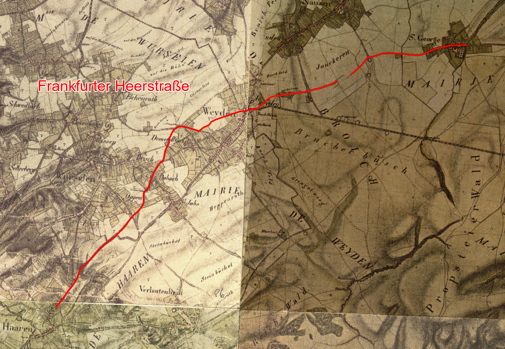
The Aachen-Frankfurt Heerstraße reaches the city limits of Würselen at the 'Alter Kaninsberg'. The further course of the Heerstraße from Kaninsberg via Weiden to Vorweiden is well known and is indicated on the following map as a red route according to the information provided by Günter Breuer, Geschichtswerkstatt Würselen. According to Breuer, the word 'Kaninsberg' actually has the meaning 'Königsberg' (King’s Mountain) and does not derive from 'rabbits' (German Kaninchen).
.png)
Aachen-Frankfurter Heerstraße through Würselen
Background map Opensteetmap (Permission)
A secured part of the Heerstraße is the ground monument B 3 of the city of Würselen, drawn turquoise on the map. It is an elongated ground subsidence that shows that the Army Road was a hollow path in this area. Hollow paths are created in 'soft' terrain due to the constant use of heavy vehicles.
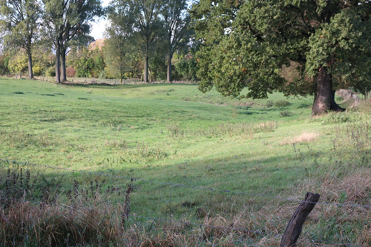
Part of the Aachen-Frankfurter Heerstraße (ground monument)
The part shown in magenta is not secured. It can be assumed from satellite images, on which the ancient road is characterized by a slightly different ground color.
Note
The satellite image of the map 'arcGIS Online' shows the traces. You can use the java software 'RoutConverter 2.26,(https://www. routeconverter.de) to have a look on it. Unfortunately, webWürselen does not have the permission to present a copy of this map here.
The course to St. Jöris of the Aachen-Frankfurt Heerstraße is probably the section reproduced here in green. It is part of the way system, which is still marked on the map from 1836-1850.
Frankfurter Heerstraße in the road net on the Tanchot map
The Fankfurter Heerstraße can be seen in the path system of the Tranchot map of about 1800. The course of the Frankfurter Heerstraße can be downloaded here as TIM-Online Projekt ("Tranchot Frankfurter Heerstrasse.json" and "WebAtlas Frankfurter Heerstrasse.json") and then easily displayed in the map service of NRW. An explanation of the procedure is here. The route is also available as a route ("Tranchot Frankfurter Heerstrasse.gpx" and "WebAtlas Frankfurter Heerstrasse.gpx").